-
 The National Weather Service has issued a Severe Thunderstorm Watch in addition to an Extreme Heat Warning
 -
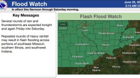
 The National Weather Service has issued a Flood Watch for the Tri-State through Saturday
 -
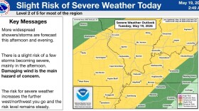
 The National Weather Service has boosted the severe weather risk to Level 2 and extended a Flood Watch through Saturday night
 -
 Just days after a tornado outbreak, the Tri-State faces a flooding risk followed by the hottest temperatures of the season — so far
 -
 The National Weather Service says it confirmed 11 tornadoes in southeast Illinois and southwest Indiana Sunday evening
 -
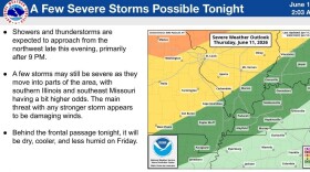
 The National Weather Service is warning of possible severe storms Wednesday night (June 17) and Thursday morning (June 18) in the Evansville area
 -
 Thunderstorms are expected to usher in slightly cooler, less humid air to the Evansville area
 -
 Forecasters have issued a Flood Watch for the Evansville area; it's in effect until Tuesday morning
 -
 The National Weather Service has recapped meteorological spring in the region; Evansville was warmer and drier that usual
 -
 The National Weather Service has issued a Flood Watch and placed the Evansville area at a Level 2 risk of severe storms

© 2026 WNIN
We're Building A Better Tri-State Together
Play Live Radio
Next Up:
0:00
0:00
Available On Air Stations


